Targeted Observation of Severe Local Storms Using Aerial Robots
Contacts
USSRG Participants
- University of Colorado, Boulder
- University of Nebraska-Lincoln
- Texas Tech University
- Texas A&M University
- University of Minnesota
Description
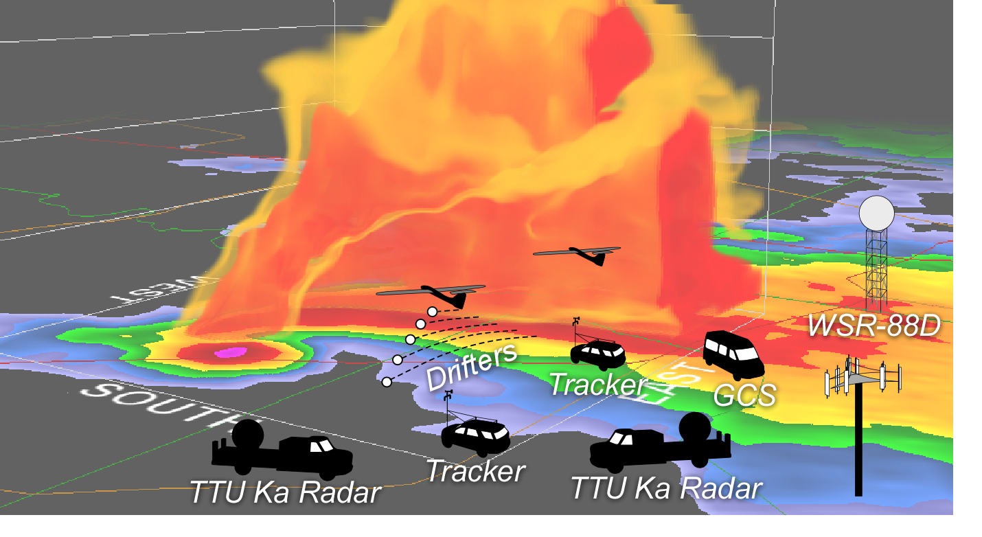
This project addresses the development of autonomous self-deploying aerial robotic systems (SDARS) that will enable new in-situ atmospheric science applications through targeted observation. SDARS is comprised of multiple robotic sensors and distributed computing nodes including multiple fixed-wing unmanned aircraft, deployable Lagrangian drifters, mobile Doppler radars, mobile command and control stations, distributed computation nodes in the field and in the lab, a net-centric middleware connecting the dispersed elements, and an autonomous decision-making architecture that closes the loop between sensing in the field and new online numerical weather prediction tools. This research aims to realize the vision of bringing cloud robotics to the clouds.
Sponsor
National Science Foundation - National Robotics InitiativeCollaboration Leading Operational UAS Development for Meteorology and Atmospheric Physics (CLOUD-MAP)
Contacts
USSRG Participants
- Oklahoma State University
- University of Oklahoma
- University of Nebraska-Lincoln
- University of Kentucky
Description
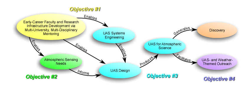
A team of four USSRG collaborators (Oklahoma State University, the University of Oklahoma, the University of Nebraska, and the University of Kentucky) have partnered to develop integrated small unmanned airborne systems (SUAS) capabilities for enhanced atmospheric physics measurements. This team will develop integrated smart unmanned aircraft technologies including advanced sensing and imaging, robust autonomous navigation, enhanced data communication capabilities, and data management tools. The team will also address public policy challenges related to adoption of UAS technology and integration of unmanned aircraft into the NAS. Scientific questions that drive the research focus include: How can local data acquired by SUAS be used to better understand larger weather phenomena? Can SUAS be used to measure large-scale patterns and trends found in the atmosphere? What advancements in operational requirements are necessary to provide routine capabilities and confidence to use SUAS as a meteorological diagnostic tool?
Sponsor
National Science Foundation - Experimental Program to Stimulate Competitive Research (EPSCoR)PRECIP
Contacts
USSRG Participants
- University of Nebraska-Lincoln
- University of Colorado, Boulder
Description
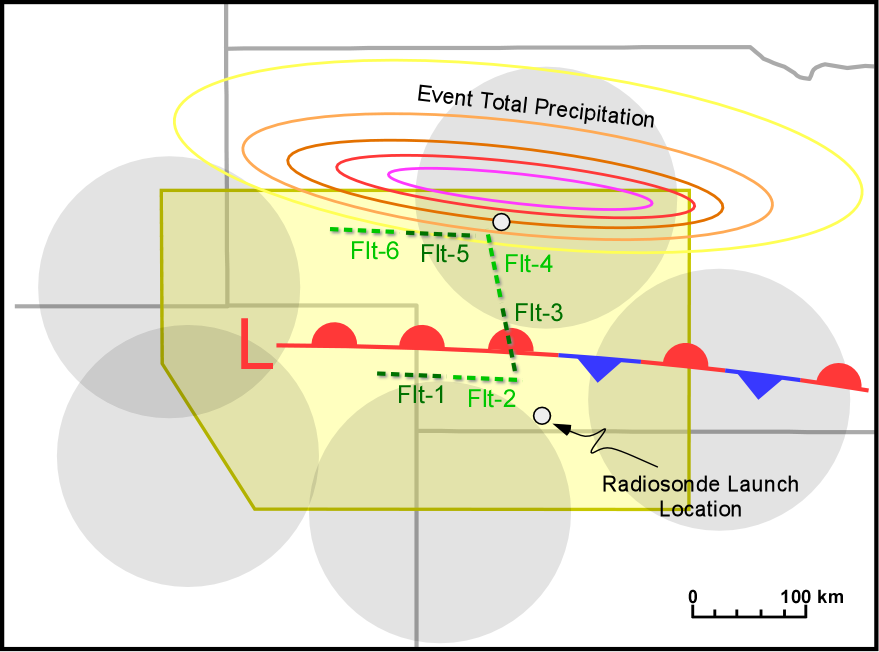
The University of Nebraska-Lincoln (UNL) and the University of Colorado Boulder will use the Tempest UAS and UNL supercomputing resources to assist in the collection and analysis of data for the Program for Research on Elevated Convection with Intense Precipitation (PRECIP) led by the University of Missouri. PRECIP aims to improve understanding of elevated thunderstorms (thunderstorms that reside on the “cool” side of frontal boundaries) that produce heavy rainfall and flash flooding. The incorporation of the Tempest UAS will augment surveillance data and supplemental data collected by the University of Missouri with UAS data collected at locations along and on the “cool” side of frontal boundaries associated with elevated thunderstorms. Additionally, UNL scientists will conduct observing system experiments (OSEs) to assess the impact of UAS observations on numerical weather prediction of heavy rain producing elevated thunderstorms.
Field deployment period
August-October 2015Sponsor
National Science FoundationEADDDAS
Contacts
USSRG Participants
- University of Colorado, Boulder
- University of Nebraska-Lincoln
- Texas Tech University
Description
The goal of this work is to create energy-aware, airborne, dynamic data-driven application systems (EADDDAS) for persistent sensing in complex atmospheric conditions. The work exploits wind energy by combining real-time, onboard and dual-Doppler wind sensing, online models for planning, and hierarchical guidance and control that can adapt to environmental, sensing, and computational resources.
Key results
- For the latest results refer to the EADDDAS field log.
- The full system was successfully tested during June 2015 field campaign.
Sponsor
Air Force Office of Scientific ResearchMET-MAP
Contacts
Dr. Jack Elston or Dr. Brian Argrow
USSRG Participants
- Black Swift Technologies
- University of Colorado, Boulder
- University of Nebraska-Lincoln
- Texas Tech University
- Colorado State University
- Center for Severe Weather Research
- Cooperative Institute for Research in Environmental Sciences
Description
The Multi-sUAS Evaluation of Techniques for Measurement of Atmospheric Properties (MET-MAP) field campaign was designed to compare UAS-borne meteorological sensors through simultaneous operation of multiple small UAS. UAS deployments targeted the morning planetary boundary layer transition and a thunderstorm gust front.
Key results
- First time multiple (3) UAS were flown simultaneously to make coordinated measurements of a thunderstorm outflow
- Simultaneous operation of 4 small UAS to sample the planetary boundary layer transition.
AVIATE
Contacts
Dr. Brian Argrow or Dr. Adam Houston
USSRG Participants
- University of Colorado, Boulder
- University of Nebraska-Lincoln
- Colorado State University
- National Severe Storms Laboratory
- Center for Severe Weather Research
Description
The Airdata Verification and Integrated Airborne Tempest Experiment (AVIATE) was conducted in June 2013 in northeastern Colorado and southeastern Wyoming. The primary objective of AVIATE was to systematically compare airborne and ground-based meteorological sensors.
Key results
Novel method developed to compare UAS-borne and surface-based meteorological sensorsVORTEX2
Contacts
Dr. Brian Argrow or Dr. Adam Houston
USSRG Participants
- University of Nebraska-Lincoln
- University of Colorado, Boulder
- UASUSA
- National Center for Atmospheric Research
- Merage Foundation
Description
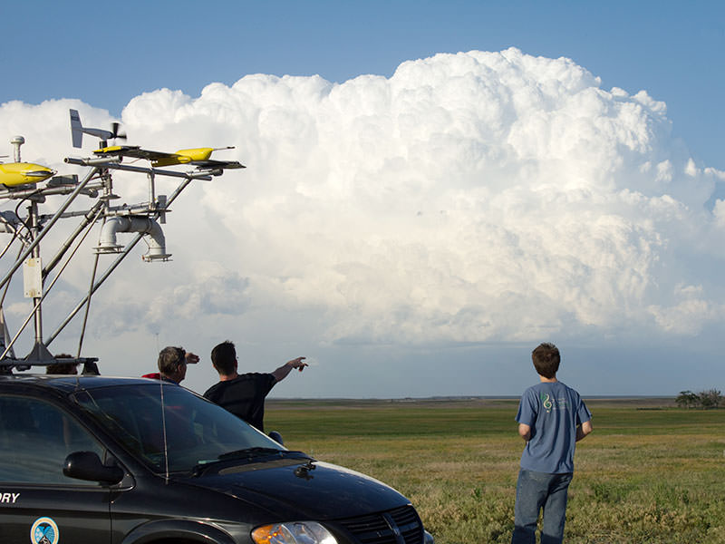
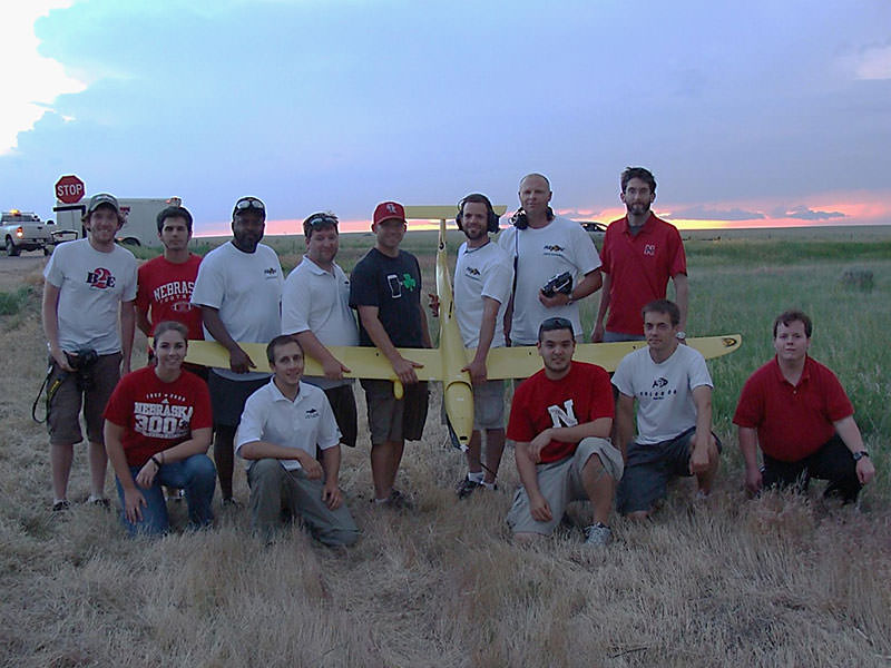
The second Verification of the Origins of Rotation in Tornadoes Experiment (VORTEX2) was a multi-institution effort to better understand tornadoes. The Tempest UAS was operated during the second year of the VORTEX2 field campaign (2010) and led to several firsts for the application of UAS to severe storm research.
Key results
- Acquisition of 59 FAA Certificates of Authorization with operation at 2 hour notice
- First-ever sampling of supercell thunderstorm outflow by an unmanned aircraft system
Sponsor
National Science FoundationCoCoNUE
Contacts
Dr. Brian Argrow or Dr. Adam Houston
USSRG Participants
- University of Colorado, Boulder
- University of Nebraska-Lincoln
- Colorado State University
- UASUSA
Description
The Collaborative Colorado-Nebraska UAS Experiment (CoCoNUE) was designed to examine the feasibility of using a small unmanned aircraft operating semi-autonomously with an onboard autopilot to observe atmospheric phenomena within the terrestrial boundary layer. The CoCoNUE field campaign was conducted in 2009 in the Pawnee National Grassland of northeastern Colorado.